"Location Intelligence solutions require world-class data. The less accurate and precise the data, the further the solution drifts from intelligence to estimates."
- Chris Tackett, Executive Director, Technology
G73 Data Solutions
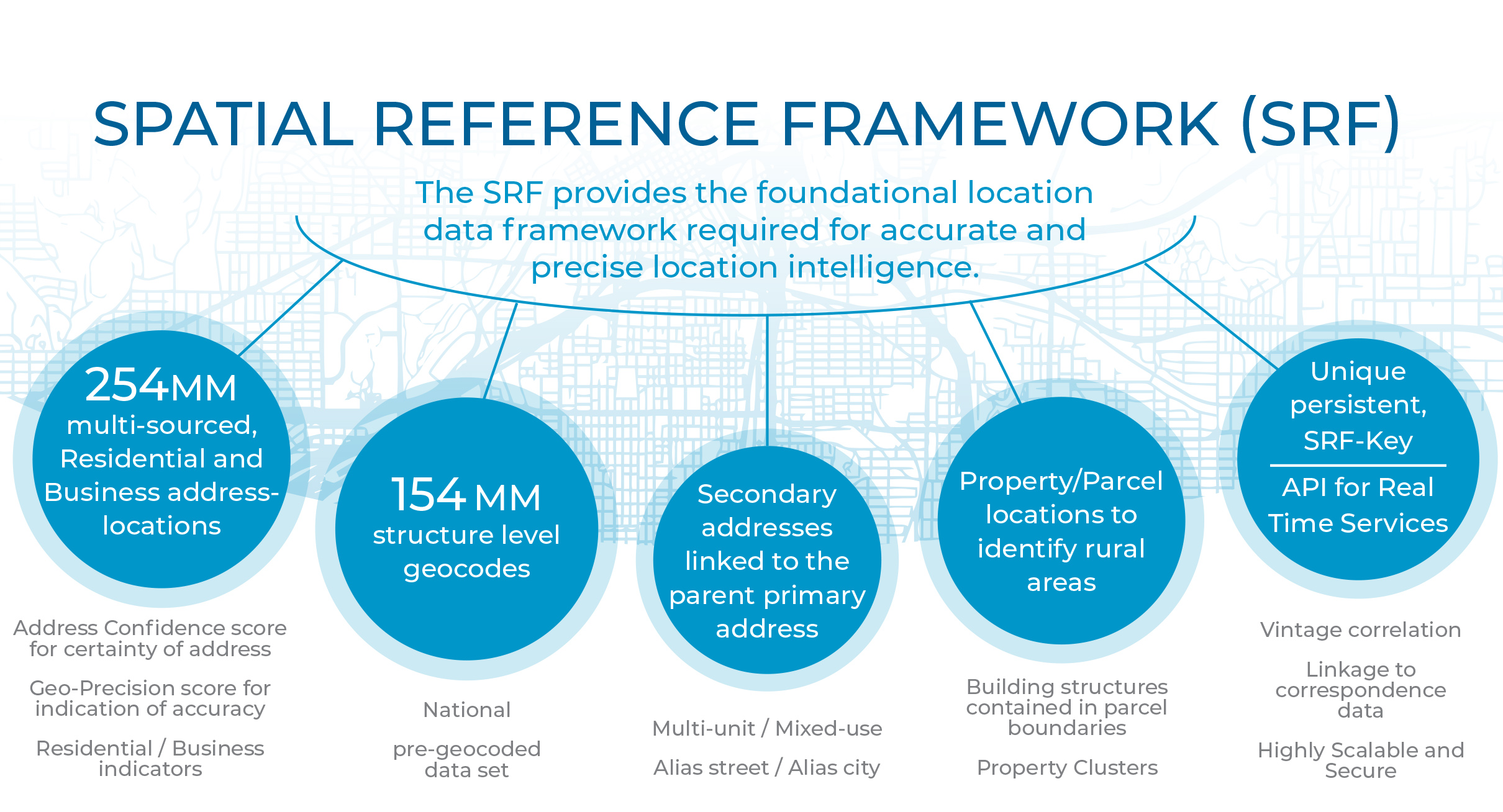
G73 Spatial Reference Framework is the foundation of accuracy and precision

Structure-level geocoding delivers higher accuracy and better decisions
Traditional geocoding services are helpful, but 'close enough' - is no longer good enough. With G73's SRF data you have a much more powerful tool for making decisions based on accurate and precise location intelligence.
Street / Parcel

Structure

Structure-level precision informs key business strategies
- Plan deployment of services and assets - network planning, technician routing
- Budget for capital investments with higher confidence
- Understand your market and ability to retain and attract customers
- Improve your risk/opportunity analysis for serviceable locations
G73 MicroBuild® geo-demographics for better decisions at the micro-geographic level
Population and household counts are changing far too quickly for census-based data sets to keep up.
MicroBuild® is a unique Location Intelligence data product designed to capture change in micro study areas:
- Census Blocks
- ZIP+4 Segments
- Street Segments
With MicroBuild® changes in household and population counts within block groups are picked up much quicker than in other data products, especially those built with census data at their core.
The example to the right indicates within one Block Group just how quickly change can happen, which can greatly impact your models and analysis when applied across your entire service area.

Here is the same block group with a satellite view.
The image on the left shows where MicroBuild® data more accurately identifies a decline in household counts due to more precise identification of the types of structures within the block.
The example on the right shows where MicroBuild® finds more households through development of new Multi-Family Dwelling Units (in this case an apartment complex) where census-based data products would fail to capture this growth.

We meet these ongoing challenges of identifying high growth, high decline and shifting demographics by leveraging our Spatial Reference Framework and Geospatial Data Science philosophy to study the most notable areas of change in population and household counts across the country.
The result offers greater levels of precision and geographic intelligence of residential population density and time-series change patterns married with area-level demographic, segmentation, and economic stability indices.
Capturing micro-geographic change in real time
We're helping our clients capture change at the micro-geographic level. The better the data, the more accurate your analysis, research and decisions.
With MicroBuild®, you can trust the data. We have patented the MicroBuild® methodology process. Current, accurate and precise geo-demographic data at the Census Block, and ZIP+4 levels to power your applications, decisions and models.